


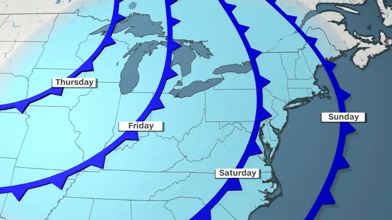


A significant weather change is on the horizon, bringing relief to millions in the South who have endured an exceptionally hot summer and a scorching start to fall. A robust cold front is set to sweep through, delivering the first gust of fall weather by the weekend and causing temperatures to drop by as much as 35 degrees.
This respite from the heat will reach as far south as the Gulf Coast, offering a much-needed break for states like Louisiana, which recently experienced its hottest summer on record. After enduring high temperatures, below-normal afternoon temperatures will finally make an appearance for the first time since spring.
The change will initially start in portions of the Plains and Midwest, where record-breaking October heat has been baking the region since Saturday. Numerous daily temperature records have been shattered, and some cities in Minnesota and Michigan have even surpassed their all-time October temperature records.
While the intense heat will soon subside in the north-central US, the Northeast will see summer-like heat building up. Temperatures 10 to 15 degrees above normal for October will be common in the Great Lakes and Northeast until Thursday.
However, this warm spell will be short-lived as the coldest air of the season is set to arrive late this week. The northern US will experience conditions not felt since early May, as a one-two punch of cold air from separate cold fronts surges across the central and eastern US.
By the weekend, high temperatures from the Great Lakes to New York could plummet by as much as 35 degrees, with a more widespread drop of around 20 degrees. The initial cold front will bring relief to states in the north-central US from Wednesday to Thursday. Cities such as Minneapolis, which recently experienced record-breaking temperatures in the 90s, may struggle to reach the 60s on Wednesday.
It is the second, more potent cold front that will truly bring the autumn air across the central and eastern US. With chilly Canadian air surging southward, cities like Detroit and Cleveland, which are expected to reach the upper 80s on Wednesday, will struggle to climb out of the low 50s by Sunday. Philadelphia and New York City, which will bask in the 80s until at least Wednesday, will see highs struggle to reach the low 60s by Sunday.
The overnight low temperatures will also see a significant drop. By Saturday morning, the north-central US and Midwest can expect temperatures in the upper 30s to low 50s, with the Northeast experiencing similar cold temperatures by Sunday morning. Northern states like North Dakota, Minnesota, and Wisconsin may even see the first frost of the season as temperatures drop into the low to middle 30s.
The chilly fall weather is expected to stick around early this month, particularly in the eastern US. The Climate Prediction Center predicts below-average temperatures from the Gulf Coast to the Northeast until at least the middle of next week.
In addition to the drastic temperature changes, stormy weather will accompany the cold fronts as cold, autumnal air clashes with warmer, summer-like air. The storm threat on Wednesday will span from the southern Plains to the Midwest, with some storms potentially turning severe in Texas and Oklahoma.
Rainfall is much needed in Texas, where 80% of the state is experiencing moderate drought conditions. From Tuesday through Wednesday, precipitation amounts of 0.75 to 1.50 inches are expected across much of the state, with some areas potentially receiving higher amounts.
As the cold fronts advance eastward, rain and thunderstorms are expected to impact portions of the eastern US on Thursday and Friday, while wet weather continues in the Midwest. The Northeast may experience periods of heavy rain over the weekend, raising concerns for areas that were recently affected by flooding rainfall.
Overall, a dramatic weather shift is underway, bringing relief from the summer-like heat, a palpable drop in temperatures, and stormy conditions in various parts of the US.