


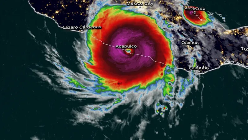


In a devastating turn of events, Hurricane Otis hit Acapulco in southern Mexico early Wednesday morning, catching officials and residents off guard. The storm rapidly intensified from a tropical storm to a Category 5 hurricane in just 12 hours, making it the strongest storm on record to strike this area and the Pacific coast of Mexico.
With little time to prepare, the sudden surge in power left people scrambling to seek safety in Acapulco, a popular tourist destination and home to around 800,000 people. As Otis approached the coast, forecasters at the National Hurricane Center warned of a "nightmare scenario" unfolding, noting that no hurricanes of this intensity had been recorded in this part of Mexico.
The eye of the storm made landfall near Acapulco with sustained winds of 165 mph around 12:25 a.m. local time, according to the National Hurricane Center. Within hours, the maximum sustained winds had weakened to 110 mph, but the dangerous hurricane-force winds extended up to 30 miles from the center. As of 8 a.m., the hurricane was located approximately 60 miles north-northwest of Acapulco.
The storm is expected to rapidly weaken as it moves inland and over the higher terrain of southern Mexico, eventually dissipating on Wednesday night, according to the hurricane center. Mexican President Andrés Manuel López Obrador urged coastal residents of Guerrero, the state containing Acapulco, to seek shelter and stay away from rivers, streams, and ravines prior to the storm's arrival.
Temporary shelters were opened in Tecpan de Galeana, Coyuca de Benítez, and Acapulco in response to the looming disaster. A hurricane warning remains in effect for the coastal areas from Punta Maldonado westward to Zihuatanejo.
The hurricane's core carries extremely destructive winds, especially on upper floors of high-rise buildings. The hurricane center also warned of storm surge, which could lead to large and destructive waves and life-threatening coastal flooding. Additionally, heavy rainfall is expected, with rainfall totals ranging from 8 to 16 inches and some areas potentially seeing up to 20 inches. This could result in flash flooding, urban flooding, and mudslides in higher terrain areas.
The rapid intensification of Otis throughout Tuesday was unprecedented in the Eastern Pacific. As the storm gained 90 mph in just 12 hours, it became the fastest intensifying hurricane over such a period in the region's history. Prior to Otis, no Category 5 hurricane had made landfall in the Eastern Pacific, with the strongest being Hurricane Patricia in 2015, which hit as a Category 4 storm.
While Patricia caused severe damage, it spared major urban areas as it traversed a sparsely populated and mountainous stretch of the coast. Otis, however, poses a significant threat due to its proximity to Acapulco. The storm's impact and ultimate toll on the region remain to be seen as authorities work to assess the situation and provide aid to affected communities.