


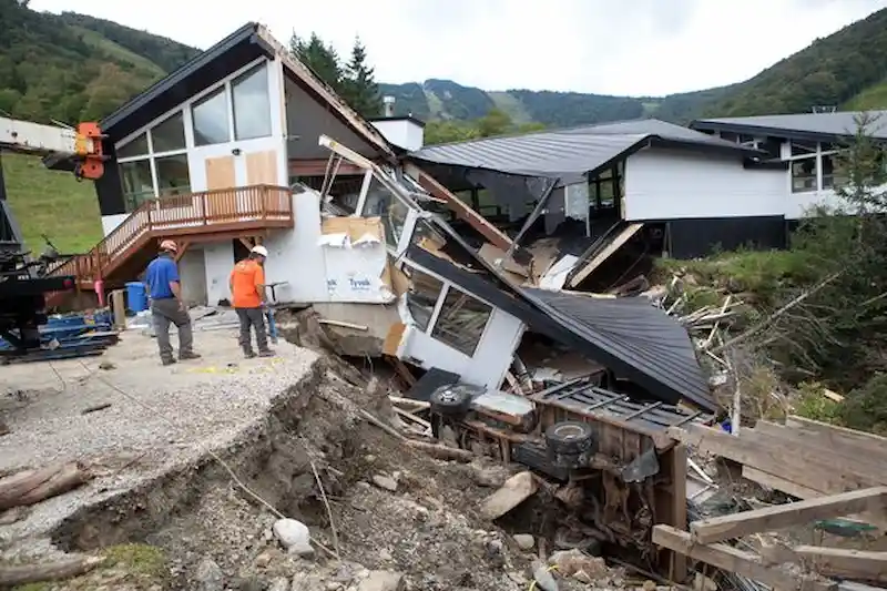


In Windham, Vermont, a wooden A-frame house that typically symbolizes winter weather now stands in the midst of a roadway-turned-river due to record rainfall. Around twenty miles away in Bridgewater, a man struggles to navigate waist-high waters while clutching his belongings. Rescuers in Montpelier, the state's capital, don life jackets and navigate rubber boats to assist in the troubled areas. Meanwhile, a helicopter crew in Berlin is involved in the rescue of three individuals and a cat named Cricket.
The state of Vermont has been experiencing a devastating flood that resembles the destructive impact of Hurricane Irene in 2011. This storm claimed eight lives, destroyed homes, and caused significant damage to covered bridges. Since then, Vermont has made notable progress in flood preparation, but the recent events highlight the ongoing threat ahead. Lauren Oates, director of policy & government relations at The Nature Conservancy Vermont, acknowledges that it has been a challenging year for the state, with a dry spring, ongoing drought, air pollution from Canadian wildfires, and now flooding. Nonetheless, significant improvements have been made over the years in terms of flood management and community resilience.
Vermont has a long history of flooding, partly due to its unique geography with north-south and east-west mountain ridges, which cause rain to concentrate. Lesley-Ann Dupigny-Giroux, Vermont's state climatologist, explains that the mountain barrier plays a critical role in setting up precipitation when air is forced to rise and cool. Additionally, the state is not far from the coast and receives Atlantic moisture from weather systems, potentially resulting in heavier rainfall.
The threat of flooding is exacerbated by climate change. As the planet warms, more heat is being stored in the oceans, leading to increased evaporation and moisture in the air, ultimately resulting in more precipitation. Both the National Climate Assessment and Vermont's own climate assessment highlight the increased risk of frequent and more severe flooding due to climate change. The frequency of heavy precipitation events in Vermont has risen by 40% since the early 1900s, with the figure expected to climb by 15% across New England.
Kevin Geiger, director of planning at the Two Rivers-Ottauquechee Regional Commission, emphasizes that the recent flood event should not come as a surprise. He states that such incidents will continue to occur in the future. Following the devastating Hurricane Irene, Vermont implemented various measures to enhance flood preparedness. The state adopted new standards for roads and bridges, sought federal funding to increase the size of bridges and culverts, and initiated a program to buy out homes in high-risk areas. Since 2011, approximately 150 homes and businesses have been purchased and demolished to create green spaces, allowing rivers to flow freely and reconnecting them to their natural floodplains.
However, Vermont still has a long way to go. Oates estimates that roughly 75% of the state's rivers are still disconnected from their historical floodplains, which increases the likelihood of overflow during extreme rainfall events. Geiger suggests that around 10,000 more homes need to be bought out to mitigate flood risks effectively.
Vermont's unique municipal structure poses practical hurdles to more aggressive climate preparation. With over 250 municipalities and no county governments, decisions and planning are often conducted at the individual town level, which can be challenging due to limited resources and small staff. The fragmentation also complicates coordination with the Federal Emergency Management Agency (FEMA) during federal disasters, as FEMA must engage with each local leader separately.
To incentivize local action and investment in hazard mitigation, Vermont's 2018 plan ties state disaster-recovery aid to the level of mitigation efforts implemented by each town. The more a town invests, the less it would have to contribute towards recovery efforts after a disaster. The plan also suggests restricting future development in risky areas known as river corridors, where flooding can cause significant damage by pushing structures downstream. However, only 10% of Vermont's towns have adopted this recommendation, indicating that more needs to be done to address this critical aspect of flooding prevention.